| 1 |
 |
|
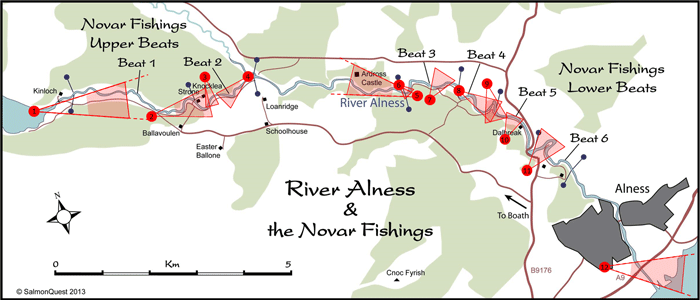
Loch Morie to Cromarty Firth
A view from above Loch Morie, looking down the Alness valley to the Cromarty Firth (~12 miles away), with part of the Moray Firth visible in the background beyond that. Novar Beat 1 can be seen in the foreground. The nearest pool visible is Burn, and the Kinloch Bridge pool can be seen in the middle of the river section, next to the track.
|
| 2 |
 |
|
Novar Lower Beat 1
Looking down on the lower half of the Ferry pool, then on to Boulder Pot, Dipper and the Flats beyond that. That's the roof of Knocklea (on Upper Beat 2) in the background.
|
| 3 |
 |
|
Novar Upper Beat 2
This photo taken from above and behind Knocklea; the Junction pool and fishing hut, Monk's, Sandpiper and the Island Run all visible. |
| 4 |
 |
|
Novar Lower/Upper Beat 2
Looking upstream from above the gorge to the Round and Slip pools (just visible), the Meadow Flats (largely obscured by a line of trees on the near bank), and the Dyke and Island Run pools, top right of the photo.
|
| 5 |
 |
|
Ardross Beat
This stunning shot is taken looking upstream to the Ardross Castle beat. The pool in the foreground is the March pool on Novar Beat 3. Beyond, there are some small waterfalls on the Ardross Castle waters, and the castle itself in the mid-distance.
Behind the castle on the skyline (about 11 miles distant), is the mountain Carn Chuinneag (838m), part of the watershed between the Alness catchment and the River Carron catchment to the North.
|
| 6 |
 |
|
Novar Upper Beat 3
This photo was taken from almost directly above the March pool at the top of the beat, looking downstream.
|
| 7 |
 |
|
Novar Lower Beat 3
This is the topmost part of Lower 3. To the far left are the Lower Parks and Ace pools, and the furthest pools to the right are Garden, and Topham's Pot. The large piece of water in the middle of the photo is not the river, but a lochan.
|
| 8 |
 |
|
Novar Upper/Lower Beat 4
This is a very deceptive view of Beat 4, foreshortened by a telephoto lens. There's not much water visible, as the tall cliffs and Douglas Firs hide the secret world of the river through this section. The bits of pools that are visible include Corner (just above the Hoch) in the foreground, the tail of Minister's (top right) and the tail of the Aggie's Bridge pool (top centre). You can also just make out the top of Raven's Rock behind the yellow field.
|
| 9 |
 |
|
Novar Lower Beat 4
The narrow 'hairpin' peninsula reaching to Raven's Rock. The Valve pool is clearly seen upstream on the right hand side, as well as part of Flat Rock. Downstream you can see Richard's Dub and Jäger beyond.
Next time we will get our pilot to fly the other side of the river!
|
| 10 |
 |
|
Novar Upper Beat 5
This photo shows the sequence of pools starting with Aggie's Bridge (partially obscured to the left of the power lines), then Boulder Rush, Ash and Mrs Perrins.
|
| 11 |
 |
|
Novar Upper Beat 6
Most of Upper Beat 6 can be seen in this photo. Island Boils can be seen in the bottom left, and Juniper downstream of that, followed by the long cascade sequence to the Goat's pool. Those are the Grilse Runs on the left hand side of the peninsula, then Otter (hidden) before the river reaches the island, that's obscuring a view of the Dam run behind. The river can then be seen again as it returns towards the camera via the Island Runs.
|
| 12 |
 |
|
Alness Estuary & Cromarty Firth
This great shot looks straight down the Cromarty Firth, past the port of Invergordon on the left, and through the two headlands known as the 'Sutors of Cromarty', about 9 miles distant, to the Moray Firth beyond. The River Alness is in the foreground, and pours into the firth via a short estuary below the A9 road bridge. The building complex in mid-shot is the Dalmore Distillery which takes water from the Alness via a lade, for use in its famous malt whisky, and also to cool the stills. |


